Cycling maps of Colchester
Explore our city (and others in Britain) using the Cyclestreets map, the Cycling UK journey planner (best for longer trips) or the Sustrans map of the National Cycle Network. There’s also an Ordnance Survey map here. Colchester Borough Council’s Cycle Colchester team has a limited number of old-school paper maps – just ask.
• Local weather
• Local tides (based on Harwich; add 40min for the Strood at Mersea.)
(NB: this isn’t déjà vu, this information is also on our front page.)
Colchester cycling routes to try
• Komoot Colchester – NB, some of these are on busy roads
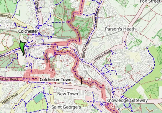
• Colchester Cycling Map
• Colchester - Sudbury - Halstead loop
• Marks Tey to Toppesfield loop
• Colchester - Kersey - Hadleigh loop
• Colchester to Stratford St Mary loop
• Colchester - Hadleigh - Raydon loop
• Colchester - Dedham - Ardleigh loop
• Colchester to Walton seaside route
• 53km Colchester to Tollesbury and return
• 67km Stour and Brett valleys; few busy roads
• Abberton Reservoir loop
• Colchester to Brightlingsea avoiding Tenpenny Hill
• Colchester to Fingringhoe via Friday Wood
• More routes based on Colchester
• Cycling to and from the port of Harwich: see link or contact us for advice
Cycle touring in England and Wales
• Tour Norfolk on the Rebellion Way
• Tour Suffolk on the Wolf Way
• Tour Hampshire and Surrey on King Alfred’s Way
• Tour Kent on the Cantii Way
• Tour North Wales on the Traws Eryri (Snowdonia)
More cycling maps
• Find a route on the National Cycling Network
• The NCN on an Ordnance Survey map
• Cyclestreets map based on London (easy to use for anywhere in the UK)
• Need more help getting across London?• Biking routes around Ipswich
Going abroad? Handy links for Europe
• Take your bike by train to Holland
• Dutch campsites
• Warmshowers for cycle tourists
• Four-day slow cycling events in the Netherlands — ideal for families
• A 116km French section of the 4,500km Eurovelo 8 route
Colchester cycling clubs
• Colchester Cycling UK runs Sunday rides at speeds of 10-12 mph (slow) – all ages and abilities. The late Alan Palmer, a CCC member for 30 years, was instrumental in getting this going.
• Happy Handlebars is a family cycling group offering short rides.
• Forty Plus is active across the county and Cycling for Pleasure (Colchester) is for those who like an occasional bimble in good company.
• For racing, sportives, time-trials or audax see Colchester Rovers, VC Revolution, Amis Velo, and VC Oyster (Mersea).